Modern cities are running on performance indicators. They move millions of people each day, concentrate capital, separate land uses, and sustain complex systems of logistics and consumption. In that sense, the city functions as a system to be continually adjusted and optimized.
Today's dominant metrics are familiar and widely witnessed: vehicles per hour, average commute times, floor area ratios, parking turnover, housing starts, and tax revenue per parcel of land. These figures describe a city that is legible through efficiency. They are inherited from an industrial logic, where urban space is treated more like a production mechanism than a lived-in environment. In this framing, cities begin to mimic the needs and metrics of a machine.
Buildner has announced the results of its competition, the Concrete Pavilion. Part of Buildner's Material Studies series, the competition invited architects and designers to explore the architectural potential of concrete through the design of an experimental pavilion. Participants were challenged to reconsider the material beyond its conventional use, investigating its spatial, structural, and sensory possibilities.
In Hong Kong, where architecture is often driven by real estate logic, infrastructure, and accelerated development, the space for bodily-scaled civic experimentation can be surprisingly narrow. This is where Design Trust has become distinctive. As a grant-making and project-enabling platform, it supports spatial interventions that sit between architecture, research, and public programming—work that is often too modest, collective, or uncertain to fit conventional client–architect pipelines.
At the center of this work is Marisa Yiu, whose leadership positions Design Trust as both an enabler and a cultural actor. Through initiatives such as Micro-Parks Hong Kong, alongside exhibitions and public programs, the organization treats discourse and prototyping as forms of spatial agency, linking designers, communities, institutions, and policy conversations while foregrounding questions of stewardship, maintenance, and the "afterlife" of public space.
Landscape and urban design studio SLA has unveiled the design for the public realm and streetscapes of Toronto's new 39.8-hectare waterfront community. The urban landscape project "Ookwemin Minising" is located in the Port Lands, an industrial and recreational district southeast of downtown Toronto, currently undergoing urban revitalization to transform the area from a former industrial zone into a naturalized river valley, mixed-use neighbourhoods, and public parkland. The overall transformation is being led by Waterfront Toronto, a publicly funded, not-for-profit corporation established in 2001 to oversee the regeneration of the area, as part of a broader government initiative to renaturalize urban areas and increase housing density. The redevelopment of Ookwemin Minising is expected to be completed in phases between 2031 and 2040.
Architecture is often evaluated through what gets built. But in many cases, what matters happens after: how spaces are used, adapted, and made part of everyday life. For Región Austral, winner of ArchDaily's 2025 Next Practices Awards, this is where design really begins. Working across many contexts, the practice approaches public space not as a single object, but as something that needs to be activated, negotiated, and sustained over time. Their projects focus less on defining form and more on creating the conditions for use, with design serving as the starting point.
This approach can be seen across different contexts, from the Olympic Neighborhood Square to the Playón de Chacarita network. While each project responds to a specific situation, both explore how public space can support collective life in areas marked by fragmentation and inequality. Instead of following a predefined approach, the work adapts to different urban conditions, using participation and incremental strategies to shape how spaces function over time.
If elevated networks reveal a city that increasingly walks above the street, the podium–tower is the typology that often makes that condition feel inevitable. Across Southeast Asia, podium–tower projects have become one of the dominant languages of metropolitan growth: a system that concentrates housing, jobs, retail, and transit connections into highly legible and managed parcels. From an urban planning perspective, the model can be remarkably effective—absorbing congestion, formalizing circulation, and delivering density quickly. Yet as it spreads, the typology also raises a quieter question: what does it optimize for, and what does it erode—especially at the level of the street, where urban life is meant to be negotiated rather than curated?
At its simplest, the podium–tower is a hybrid structure consisting of a high-coverage, low-rise podium supporting one or more slender vertical towers. The podium typically carries the logistical and commercial weight of the development—retail, parking, loading, drop-offs, back-of-house services, and often amenity decks—while the tower stacks private programs above, whether residential, office, hotel, or mixed use. The promise is twofold: maximize urban density while maintaining a "human-scaled" street wall, and separate the messy logistics of city life from the quieter domain of living and work.
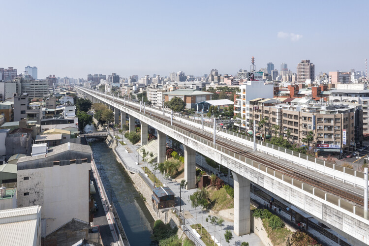
Elevation is often framed as progress, lifting movement above the friction of the city and smoothing circulation into uninterrupted flow. Every act of lifting produces a secondary condition in its wake. Beneath flyovers, metro lines, and railway viaducts, a second ground emerges as shaded, ambiguous, and rarely planned with the same intent as what moves above. These spaces are not incidental leftovers. They are the spatial consequence of a design decision that privileges speed, clearance, and efficiency, redistributing value and visibility across the city in the process.
What lies below is not empty. It is structured, constrained, and defined by infrastructure, left without a clear role. Studies on elevated highways consistently describe these undercroft zones as residual spaces, formed when transport systems are conceived independently of the ground they pass through. An Arup report on spaces beneath viaducts notes how they often disrupt pedestrian continuity while remaining outside formal planning frameworks. Similarly, recent academic reviews of under-flyover environments highlight that these areas are rarely integrated into urban design strategies at all. The result is a peculiar condition: space that is physically present and structurally determined, but programmatically undefined.
In 2012, Cities Without Ground: A Hong Kong Guidebook offered one of the clearest documentations of a condition that many residents experience intuitively but rarely name: Hong Kong's dependence on elevated, second-storey urbanism. Through drawings and careful mapping, the book captured how the city's pedestrian networks are routinely lifted above the street—separating people from traffic, extending commercial frontage beyond ground level, and negotiating a hilly topography where "flat" circulation is often an engineered achievement. Since its publication, these systems have only grown in prominence—not only for their sheer spatial complexity, but for the way they recast public space as something continuous yet selective, connective yet curated.
This fascination, however, has always carried a parallel unease. Elevated passages can be generous and effective, offering sheltered movement and reliable connectivity. Yet they also raise persistent questions: where do these routes lead, who gets to connect, and what kinds of programs are invited—or excluded—by this "privileged" level of circulation? The second-storey city does not simply bypass vehicles; it can also bypass the street as a civic stage. Over time, it risks shifting architectural attention away from ground-level public life, relieving designers from having to negotiate pedestrian scale, frontage, and the messy reciprocity of the street. In its worst moments, the result is a landscape of podium clusters and sealed megastructures—buildings that perform connectivity at Level 2 while remaining indifferent to the neighborhood at Level 0.
What do lightweight materials bring to public space with an ethical, ecological, and non-extractive design principle? Various textile textures offer a point of entry, being closer to the body than heavy conventional structural materials. Through its flexibility and responsiveness, it enables a form of soft enclosure rather than a fixed boundary in architectural space. Responding to minimal environmental stimuli, the fabric brings continuous movements into space. When layered or assembled, it produces gradations of density, depth, and enclosure, while recent innovative fabrication technologies extend the possibilities of its form and structural durability.
Semi-transparent materials further mediate the conditions of visual permeability and bodily experience of the space. By transmitting and filtering light, they blur clear separations between interior and exterior, solid and void, creating thresholds that are neither fully open nor fully enclosed, but constantly in negotiation. Reinterpreting structure in urban space through lightweight, translucency, and softness opens up alternative modes of spatial perception and bodily engagement.
Architecture has long been drawn to the idea of lightness. From early modernist experiments that sought to preserve landscapes, elevating buildings has been understood as a way to preserve the ground while maintaining continuity across the terrain. Volumes are lifted on columns, infrastructures detach circulation from the surface, and entire programs are suspended above the ground.
This was formalised in the early twentieth century through Le Corbusier's concept of the pilotis, which proposed the liberation of the ground floor from enclosure. By raising buildings on columns, architects sought to maintain continuity with the terrain, allowing movement, vegetation, and collective use to unfold beneath constructed volumes. The building would occupy the air, while the ground would remain open, accessible, and shared.
In recent decades, cities across the world have seen an increase in the demolition of elevated concrete freeways. Taipei, Seoul, Portland, and Boston, for example, have all seen the rise and fall of these infrastructures to give way to parks and new urban regeneration ideas. In other cases, like Montreal in Canada, some people opposed the freeways even before they were built, effectively rerouting viaducts, preserving heritage, and freeing waterfront views. For San Francisco, in the United States, the story of the Embarcadero Freeway is one of those narratives that serves as a case study of the city's mid-century infrastructural ambition, people's reaction to the project, and its eventual reversal in favor of urban connectivity.
Paris's 19th arrondissement Parc de la Villette is undergoing a major transformation, combining a newly opened urban farm with restored biodiversity as part of a strategy to adapt the 55.5-hectare park to climate change. Masterplanned by Bernard Tschumi in 1982 and opened to the public in 1987, the park stands as a landmark of European modernism in public space design, breaking from the traditional concept of the metropolitan park. With a 15,000-square-meter extension, this major green lung in northeast Paris is reimagining its lawns as a living laboratory for environmental education, where animals, plants, and humans coexist. The extensive renovation follows the addition of Tschumi's HyperTent in 2022, a hyperbolic paraboloid structure functioning as a new ticket booth on the podium of Folie L4, and marks the park's most significant transformation since its inauguration.
Cultural centers continue to serve as a productive ground for unbuilt architectural exploration, reflecting how architects are rethinking the role of public institutions in relation to landscape, experience, and program hybridity. In this Unbuilt edition, submitted by the ArchDaily community, the selected projects bring together a range of proposals that expand the definition of the cultural center beyond a singular building. These works position architecture as a spatial framework that mediates between research, exhibition, retreat, and public life, often embedded within or distributed across natural and urban contexts.
Across varied geographies, from northern Norway and Oslo to Łódź, Vienna, Marrakech, and New Tashkent, the projects demonstrate diverse responses to cultural infrastructure. They include landscape-integrated complexes shaped by topography and climate, bridges that combine gallery and public circulation, zoological pavilions structured as immersive sequences, adaptive reuse of military buildings into performance spaces, courtyard-based environments rooted in local traditions, and climate-responsive institutions informed by environmental analysis. Together, these proposals explore how cultural programs can be organized through movement, spatial layering, and relationships between interior and exterior conditions.
Death is a certainty, but its architecture has never been stable. Every period and culture has invented a different way of placing the dead in the world (close or far, visible or screened, monumental or almost anonymous), and those choices have always carried social and political weight. Cemeteries are where that weight becomes legible in space, turning belief and regulation into boundaries, paths, and names.
In that sense, a cemetery behaves like a piece of city-making. It needs access, limits, and an internal order that can grow without losing clarity. It depends on ground and water management as much as on symbolism, and on administration as much as on form. But its real architectural problem is how to make a large, evolving territory readable while preserving the intimacy of a visit. Names must be locatable; routes must remain legible; trees grow, paths shift, stones weather, records accumulate. What looks fixed is, in practice, a living system designed to be used and revisited, long after the first grief has passed.
This week has been marked by the deliberate, rampant, and unjust destruction of war in Southeast Asia. As one of the most damaging manifestations of human abuse of power, we have witnessed the destruction of places that hold memories and sustain culture, as well as the loss and irreparable harm to the human lives that lend them their identity. With the expectation of offering brighter and more constructive scenarios in the future, we present, in contrast to this reality, a scenario of progress in the gender gap that characterizes architecture and its paths forward, a group of landmark projects of public and community interest moving forward from Türkiye to Mexico, and three major multimodal transport infrastructure projects improving the way we circulate and inhabit public space in Europe and the United States.


")
")
")
")


. Image © VMA Design Studio")


