There are significant deficiencies in how our cities worldwide operate and serve the people who live in them. Bureaucracies, red tape, and other limiting processes that publicly drive our cities towards their futures are often the aspects that cause change to happen at such a slow pace that by the time an issue is addressed, five more have popped up in its place. Over time, society has come to accept that when the systems we have in place don’t do much to serve our needs, it forces us to turn to alternatives to advocate for change. Some urban issues have found the best solutions after initiating social movements and the formation of grassroots groups.
How we plan our cities, suburbs, and rural communities is a constantly evolving set of goals essential for creating sustainable cities. Not only do we need to consider what lies within these areas, but we also need to effectively design the boundaries between each, where urban meets suburban, and where suburban meets the small town. In recent years, urbanists have paid close attention to urban sprawl, or what sometimes happens when towns rapidly grow outwardly from city centers. What happens when cities seem to “sprawl” out of control, and are the design principals behind New Urbanism able to turn urban sprawl into equitable communities?
Chicago, The Windy City, Chi-Town, or The Second City. It’s a place that is known by many names, but to architects and urban planners alike, it’s famous for its history which has given us some of the best-known buildings and important advancements that have helped to shape other cities across the United States. From its inception, Chicago has long served as an architectural hub for innovation.
Courtesy of Urban Agency | COBE | LuxPlan |Urban Creators
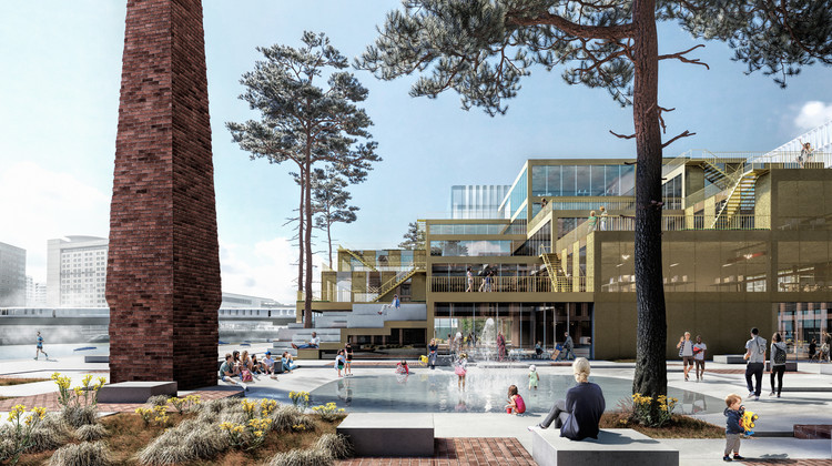
Urban Agency, in partnership with COBE, won in 2019 a competition to transform a former steel factory into an 850,000 square meters car-free mixed-use district. The industrial site is planned to become a mixed-use district, with housing for over 8,000 new residents, office spaces, schools, workshop spaces, and 268,000 square meters of landscape, including a reactivated river area. The master plan strategies focus on urban nature, renaturalization, preservation and reuse, car-free streets, and an adapted dense mix of buildings and functions.
The great debate wages on: how do we design and build a modern city in a way that everyone will benefit? Traditionally, you’re on one side of the urban war. You’re either a NIMBY, which stands for “Not In My Backyard”, meaning you oppose new development in your neighborhood, or you’re a YIMBY, who says “Yes In My Backyard”, and are pro-development, for one reason or another. But these blanket acronyms don’t describe the real issues that cause people to position themselves on one side of the never-ending tug-of-war between “No! Don’t build that!” and “Yes! Build that!”
Last week, the Global Designing Cities Initiative (GDCI) released Designing Streets for Kids to set a new global baseline for designing urban streets. Designing Streets for Kids builds upon the approach of putting people first, with a focus on the specific needs of babies, children, and their caregivers as pedestrians, cyclists, and transit users in urban streets around the world.
We say that with confidence knowing the city’s demographics (nearly 80 percent African-American and with one of the highest poverty rates in the United States) present unique challenges to providing economic opportunity. And we say that with certainty knowing that a pernicious history of redlining, loan discrimination, and other inequities has denied Detroit’s Black majority the kind of power and say-so in design and economic development that would produce more favorable outcomes.
There are few more powerful questions than “Where are you from?” People feel intensely connected to cities as places and to other people who feel that same kind of connection. In other words, we tend to understand and experience places in a very personal way.
Yet to understand place—indeed, to understand human settlements in general—it’s important to recognize that places are not created by accident. They are created on purpose to further a political or economic agenda. Better cities emerge when the people who shape them think more broadly and consciously about the places they are creating.
Social responsibility and the desire to improve society has long been influenced by the built environment. Looking at city centers, architecture has contributed to the improvement of the urban fabric, whether it being through planning and zoning strategies, integration of public spaces, or small interventions. In some cases however, these interventions are in fact used as tools to keep the homeless off the streets, disguised as art or conceptual designs. Several public urban policies have all implicitly prohibited the homeless and other marginalized social groups from city centers, claiming that their presence and “irregular” use of public space could compromise the reputation, security, and desirability of the city.
Ennead Architects has unveiled the Shanghai Lingang Special Area master plan, a new hub for global commerce. Designed around the central axis that defines the Dishui Lake district in Shanghai, the master plan establishes the identity of a new business district. Designed as a free trade zone, this is planned to attract prominent international companies. The site's design proposes functional areas where multinational corporations can optimize business operations while creating open spaces for the surrounding communities. Ennead’s large-scale plan includes four commercial buildings, retail, civic and open spaces.
Cities face much criticism with how they handle their car population, but have you ever thought about how much land use is dedicated to surface parking lots? In fact, it may be one of the most prominent features of the postwar city in the United States. Housing, community facilities, highway infrastructure, often garner much attention, but the amount of land dedicated just to park cars is astounding.
The concept of an “ideal city” is something that is often talked about today, as we look towards the future and think about what aspects of urban life we feel are most important for residents to thrive in a healthy community. However, ideal cities were conceived during the Italian Renaissance, as planners and architects prioritized rationale in their designs focusing on human values, urban capacities, and the recursive waves of cultural and artistic revolutions that influenced large-scale planning schemes.
Heatherick Studio has revealed the redevelopment plan for Nottingham city centre, a vision that establishes a new green core, reshapes the former shopping centre at the heart of the site, and highlights the area’s touristic potential. Centred around an ample new green area enabling citizens to connect with nature, the project proposes new social spaces, commercial, mixed-use and residential buildings while establishing street connections around the city centre. The initiative represents an expansive vision for redefining the city centre and its programming amidst the evolution of retail towards online shopping and in response to the impact of the pandemic.
The way our world looks like today is a result of centuries and centuries of human migration, of complex natural phenomena that has resulted in the geographic appearance of the world’s continents today. We understand this world through our lived experiences, but we also understand this world through a two-dimensional man-made invention – maps. Maps define the many contested borders of the world and have been used in an oppressive capacity, in particular places, for example, segmenting off sections of a place from marginalised societal groups.
The development of cities has historically been a slow-moving process. In the everchanging urban landscape that faces the pushes and pulls of a variety of social, economic, and financial factors, it’s been hard to pinpoint just one main reason over another why each city has evolved over time into the way that we experience it today. And as designers and planners speculate about what the future of our cities should be, sometimes the reason that our cities look and operate in the way that they do has come down to a few famous battles between individuals with competing schools of thought.
Courtesy of UIA / International Union of Architects
Chinese architect and town planner Wu Liangyong was recently featured in a new interview from the International Union of Architects (UIA) about his life and teaching. As the former Vice-President of the UIA and the Architectural Society of China (ASC), Liangyong won the Jean Tschumi Prize back in 1996. Today, he reflects on his academic career spanning 70 years at the Tsinghua University School of Architecture.
Aerial view of the Hanford Construction camp. Image Courtesy of National Archives and Records Administration
In 1942, less than a year after the United States was pulled into World War II, the U.S Army Corps of Engineers quickly and quietly began acquiring large parcels of land in remote areas in three states. Soon after, thousands of young designers, engineers, planners, scientists, and their families, began arriving at these sites that were heavily shielded from public view. Workers there constructed hundreds of buildings including houses, industrial structures, research labs, and testing facilities at unprecedented speed and scale.
The Henning Larsen-designed Belfast Waterside development was officially granted planning approval by the Belfast City Council, after a year in the planning approval process. Located on the site of the former Sirocco Works, the project is set to “transform the 2.6-hectare area on the east bank of the River Lagan that has been disused for nearly two decades”.


")


 project in Dragão do Mar in August 2018. Before, only 32% felt safe or very safe from motorized traffic. After Cidade da Gente, this proportion went up to 86%. Image Courtesy of NACTO-GDCI")


 prototype, 2015. Image Courtesy of Skidmore, Owings & Merrill LLP")