As income inequality has widened in recent years, the role of philanthropy has been called into question. Is charitable giving by wealthy individuals and powerful corporations always a positive force, or is that connection to wealth and power an inevitable compromise? Whose agenda does philanthropic giving really benefit, the grantees or the granters? These are complicated questions. But truly enlightened giving is a transformative force. It can not only fund worthy causes but if properly timed can sow the seeds of social change.
Religion is a uniquely human reality. As are cities. As we emerge from our burrows of sequestration, the silent cities and places of worship will become human again, versus the present sad memory of what they once were.
We will recover from another human reality, the pandemic and when we do we will be forced to address some questions. Before this century, the automobile was once seen as the way Americans could create a new reality: a huge middle class that could control its life by using the freedom that cars gave them to go where they wanted, when they wanted, and to live where they wanted. Before this latest change of sequestration, that vision of what cars meant to our culture was changing —especially in cities.
UVA La Esperanza in Medellin, Colombia. Image Courtesy of EPM
Social Urbanism: Reframing Spatial Design – Discourses from Latin America, a new book by Maria Bellalta, ASLA, dean of the School of Landscape Architecture at the Boston Architectural College, is a welcome addition to the growing number of publications on the social justice-oriented form of urbanism, architecture, and public space emanating from Medellín and Colombia. The achievements of social urbanism have rightfully become synonymous with Medellín in the world of landscape architecture, urban planning and design, and architecture.
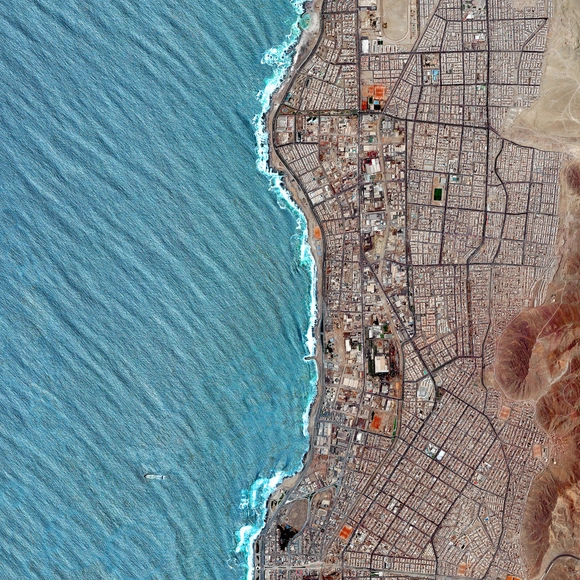
Antofagasta, Chile. Created by @overview. Source imagery: @maxartechnologies
“There seems to be a public image of any given city which is the overlap of many individual images," American urban planner Kevin Lynch once said. "Or perhaps there is a series of public images, each held by some significant number of citizens,” he added.
Following this remark, in his book "The Image of the City" (1960), Lynch begins an analysis around the elements that constitute what he considers to be the image of the city. While introducing, describing, and illustrating these elements as physical, perceptible objects, Lynch considers that other non-physical factors such as history, function, or even the name of the city also play a significant role in the construction of this imageability.
Do you feel vulnerable as you walk through public spaces? If you are a woman, the odds of answering yes to this question are certainly greater since men are less likely to choose a longer route only to avoid a dark section of the street, or to ponder on what clothes to wear so that they do not feel exposed in public. In this sense, it seems almost obvious that cities designed by men should be perceived as threatening environments, rather than a place where women feel welcome. So, to imagine egalitarian cities, should we persist in a reflection of a gender-oriented approach?
https://www.archdaily.com/956585/how-can-gender-impact-the-future-of-urban-lifeCamilla Ghisleni e Victor Delaqua
Understanding what drives economic, social, and educational disparities between communities is one of urbanism’s most critical and highly-discussed topics. It’s an increasingly complex issue, with many factors at play- one of them being the design and location of desirable urban green spaces. While sometimes they are a tool that helps to bolster underserved communities in terms of health and economic benefits, safety, and climate resistance, other times they can actually drive out the residents that they are created to serve. Now, the challenge lies in how to design these recreational sites to create better futures for all.
As long as cities have been around, there’s been one pressing question central to their future: “What makes urban areas desirable?” Over half of the world’s inhabitants live in cities and that number is projected to climb over the next decade with more than 5 billion people inhabiting urban cores globally. To prepare for this demand, cities are finding ways to be more desirable, draw in talent, and entice both big and small businesses, all while finding more ways to create equitable living opportunities for all.
Think about the city or town where you live. How long does it take you to get to the grocery store on foot? Is your school or work close enough to walk to? What about a public park, a doctor’s office, a daycare, or any other places that you visit on a daily basis? While some cities have already considered what it means to live near all of these necessities, others are revamping their urban planning strategies and designing their neighborhoods to be more pedestrian-friendly with the concept of a “15-Minute City”.
Mohammed bin Salman, Crown Prince of Saudi Arabia, has unveiled plans for a 100-mile long linear city called The Line. Announcing the project in a new video, the city would include a series of walkable communities for a million people with no cars or streets. The project locates essential facilities within a five-minute walk of housing, connected "modules" linking the Red Sea coast with north-west Saudi Arabia as part of the NEOM city-state.
Whether as a retrospective, a collection of contemporary works, or a compilation of prospects for the future - and all the other possibilities in between -, architecture and urban planning exhibitions have played an important role in shaping the future of cities over the decades. These events are often open to the public, reaching many people who don't necessarily have a background in the field, thus providing great environments to explore a collective view of the future of architecture and cities.
Many initiatives around the world have lately focused on ways to improve the urban environment through the actions of their inhabitants, be it in designing, building, or managing projects. Open-source urbanism is a collaborative approach that seeks to enhance the citizens' capacity for change.
An in-depth look at the concept of open-source urbanism is happening nowadays, and one can find many different definitions and approaches to it. But overall, open-source urbanism can be defined as the co-production of open-source common urban assets.
Dublin Bridge Park in Columbus, Ohio. Image via Dublin Bridge Park
Suburbs as we know them are changing forever. Partially exacerbated by the effects of the pandemic, residents are leaving cities in droves in search of more favorable living conditions where more space, privacy, and affordability offers what some consider to be a more comfortable lifestyle. But as time goes on, and development sprawls, it’s harder to tell where cities end and suburbs begin.
I attended graduate school, in geography, in Tucson, Arizona, United States, in the late 1990s. Tucson draws fame from a number of things, including its Mexican-American heritage, its chimichangas, its sky islands, and its abundant population of saguaro cacti.
Cities would be nothing without the sense of experimentation and the future-forward push to always break the status quo in demand of a better urban life. As many successful urban designs and strategies as there have been, the world has also seen some not-so-successful ones, that have been pushed to the sidelines becoming a forgotten memory over time. While we look ahead and speculate about what the future of cities could and should be, maybe it’s time to take the lessons learned from these failed projects and pay homage to their misfortunes, so that history’s mistakes aren’t repeated in the present day.
Before the pandemic, the world was already facing a series of global transformations in the field of construction, where emerging countries were at the forefront of a powerful economic shift. As the world's population is expected to reach the 10-billion milestone before 2100, the construction sector should be able to understand and adapt to the megatrends that are reshaping the globe.
In his book Breve Historia del Urbanismo (Brief History of Urbanism), Fernando Chueca Goitia states that the medieval city appeared at the beginning of the 11th century and flourished only between the 12th and 13th centuries. According to the author, this growth was closely linked to the development of commerce that allowed permanent occupations, resulting in a city no longer composed mainly of travelers. In other words, the bourgeoisie was formed thanks to the most diverse activities - craftsmen, tradesmen, blacksmiths, longshoremen - which stimulated the development of the medieval city.
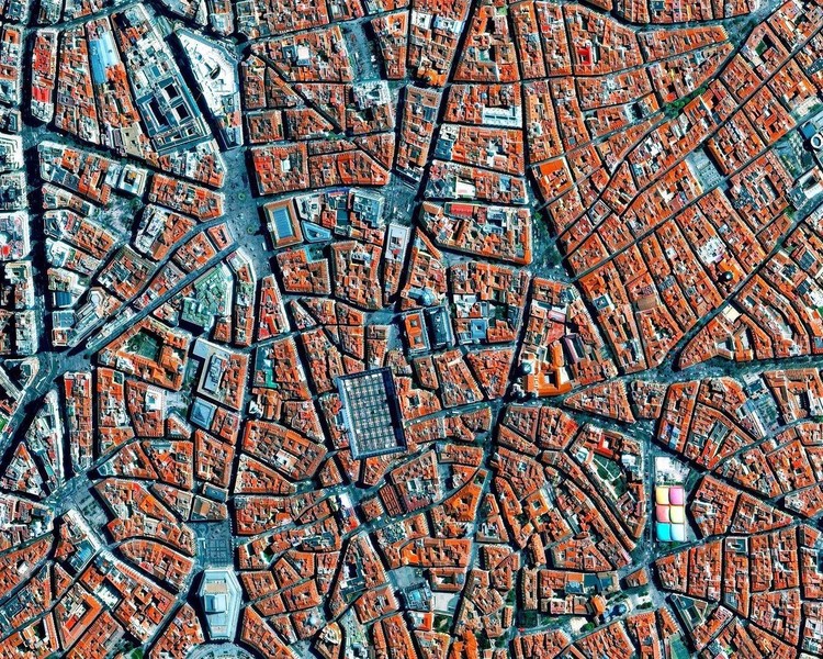
A radial concentric city plan is formed by streets that extend outward from a defined center and reach the outer edge of the city, together with concentrically arranged roads that connect the radial streets to the lots. This pattern traces back to ancient times and continues even to this day.
Depending on the historical context, location, or purpose of the city planning, the element found in the center may vary. Plazas, churches, or government buildings are among the most common elements and this is no accident, nor is the urban design pattern. Basically, the radial arrangement of streets is intended to highlight a particular element or location that has great political, religious, financial, or symbolic value to the city as a whole.


_8803.jpg?1610126390 "\"Refugee Heritage\" Exhibition at the 2019 Chicago Architecture Biennial / Ana María León and Andrew Herscher. Photo: © Laurian Ghinitoiu")


.jpg?1608057697&format=webp&width=640&height=580)