American graphic designer Peter Dovak is passionate about urban transportation. He has creates colorful designs that represent transit systems in a much more instructive way so that people can interpret them more easily.
One of his last projects, called 220 Mini Metros, was based on metro and light rail networks from 220 cities of the world.
Designing urban spaces to improve mobility for all inhabitants is one of the main objectives of NACTO, the National Association of City Transportation Officials. Founded in 1996, this non-profit organization brings together more than 40 US and Canadian cities to share their advice and design practices seeking to raise the design standards in public policies for public spaces, mobility, and transportation.
They’ve developed a series of guides in which they propose design guidelines to make streets, cycle paths, intersections and other urban spaces more accessible and safe for all road users. One of the most recent is the "Transit Street Design Guide" in which they offer, among other things, 6 recommendations to take into account when designing bus stops. Find out what these recommendations are below.
The importance of public spaces in urban life is an issue that has been apparent since ancient Greece and is still with us today. Opportunities to meet and exchange ideas in these spaces are able to influence how the inhabitants participate in the development of their city, and occur in greater instances when public spaces are accessible to everyone.
However, in modern societies, the strategic role of these spaces has been limited. According to The City Fix, a blog on sustainable urban planning, one of the main reasons for this is the overabundance of automobiles. In fact, according to one study by the Brazilian Institute for Energy and the Environment, 70% of public spaces in urban centers are taken up by roadways and other spaces for cars, while car owners make up only around 20 to 40 percent of the city’s population.
How can public spaces be recovered to promote urban life? We discuss three important factors below.
This month, in the city of Xiamen, China's first elevated cycling path was inaugurated. At nearly 8 kilometers long, the structure is now the world's longest elevated cycling path.
The construction of this exclusive cycling path was promoted by the Xiamen City Government to provide inhabitants with a new sustainable transportation alternative that could significantly reduce vehicular traffic on the city's already congested highways.
Vision Zero is an initiative that started in Sweden in 1997 when the country began implementing a series of road safety measures to reach their goal of zero deaths from traffic accidents. As a result, the country managed to reduce the number of deaths to 3 people per 100 thousand inhabitants.
Since then the plan has been adopted by different cities and has inspired the creation of various organizations that are looking to make our streets a safer places. One of them being the Vision Zero Network that brings together traffic engineers, health professionals, local leaders, and policy makers.
Planning can be a complex task depending on the factors at play such as time, participants, and topics.
Since 2012 a Swedish firm called MethodKit has dedicated itself to designing kits to simplify task in many professional disciplines using cards that raise an issue and guide the discussion.
Initially, these kits were oriented towards design and digital technology, however, with such a collaborative and easy to use tool they were expanded to architecture and urban planning.
"Rethink the City; New Approaches to Global and Local Urban Challenges" is a free online course given by Delft University of Technology in the Netherlands, starting on March 28, 2017.
The course aims to address urban challenges in emerging countries to provide a new perspective in understanding and analyzing the southern hemisphere. For this reason, the content is structured in the following three thematic axes: "Spatial Justice," "Housing Provision and Management," and "Urban Resilience".
Enrollment is now open through the Edx.org online education platform. The course has a duration of six weeks between 3 to 4 hours per week and is aimed especially at undergraduate students, especially those in Latin America, Asia, and Africa, according to the course content.
Pedestrians, the most vulnerable users of road space, will now be more visible to drivers in the Netherlands with the inauguration of a new luminous pedestrian crossing this past November in Brummen, west of Amsterdam.
Designed by the Dutch firm Lighted Zebra Crossing, and installed free of charge for the municipality, this crossing makes pedestrians more visible at night or during bad weather. Each of the lines has two plates of lights that at night remain illuminated at all times and not only when there are people on them.
Danish architect Jan Gehl is a world renowned expert in all things related to urban design and public spaces. He obtained this expertise by publishing numerous books, and later, from his consulting firm Gehl Architects that he founded in Copenhagen, his hometown, to make cities for people. The firm celebrated its 50th anniversary in 2016.
Unequal distribution of public space when it comes to pedestrians, cyclists and people driving cars is an issue that urban mobility specialist Mikael Colville-Andersen calls "The Arrogance of Space."
The urban planner and founder of Copenhagenize believe that this term can be applied to streets that are dominated by traffic engineers from last century where streets were made primarily for cars.
To illustrate his position, Mikael analyzed the amount of space allocated to each of these groups, in addition to "dead space” and space for buildings, in the streets of Calgary, Paris, and Tokyo by comparing each sector using different colors.
The latest publication of the National Association of City Transportation Officials, NACTO, is the "Transit Street Design Guide" in which tips and proposals are presented on how to improve streets through urban design.
The ideas are centered on prioritizing sustainable mobility so that both the member cities of the organization and those that have access to this document can improve their practices in relation to public spaces, mobility, and transportation.
Over the last few years, the way Americans move around has changed remarkably, especially among young people. Previously the automobile was people’s preferred, if not the only, option. Now they are choosing to walk, bike, or use public transport according to recent studies.
This difference in preferred transportation methods has generated many benefits not only for residents but also for cities, in both economic and social terms.
Building a highway in a city is often thought of as a solution to traffic congestion. However, the induced demand theory has shown that when drivers have more routes, they choose to continue using this medium instead of using public transport or a bicycle, and as a result, congestion doesn’t decrease.
As a result, some cities have chosen to remove spaces designated for cars and turn what was once a highway into urban parks and less congested streets.
Here we have six examples, some have already been completed, while a few are still under construction. To the surprise of some, most of the projects are in the US, which reflects that American designers are looking into further studying European transport policies.
Public spaces, squares, and parks in New York City are administered by the city’s Department of Parks & Recreation (NYC Parks).
In recent years, the agency has been responsible for creating new programs to help children, youth and adults be aware of the importance of caring for their urban landscape.
One of these programs is a TreesCount! which in 2015 gathered 2,300 volunteers to learn about the trees in their environment, what state they are in, what care they need, what their measurements are, and how they benefit the surrounding community, etc.
For months, they walked the streets of the five boroughs together with a group of monitors who previously trained them to recognize what trees they were studying and their characteristics.
Padre Alonso de Ovalle, Santiago, Chile. Image Courtesy of Urb-I
Providing more public space for pedestrians is one of the main goals of urban renewal projects taking place in cities around the world.
By planting more trees, implementing more sidewalks and bike paths and establishing new seating areas, it is possible to design more welcoming places with less traffic congestion and that promote sustainable methods of transportation, such as walking or biking.
With the aim of publicizing urban renewal projects that have made cities more pedestrian friendly, Brazilian group Urb-I launched the “Before/After” project, which compiles before and after photos that show how cities have redistributed their public space.
The project is collaborative so that anyone can use Google Street View, or another similar tool, to raise awareness of the changes taking place in their cities.
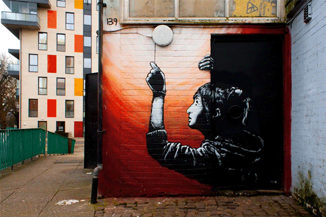
Spanish designer and photographer A.L. Crego has brought street art to life in his latest project, adding movement to murals from the around the world. In order to maintain the original artwork, Crego first photographed the sites and then digitally intervened to convert them into animations.
All the murals selected by the designer convey messages about dependence on technology and its effects on personal interactions.
Well-designed, protected bike lanes are not only the desire for riders, but a necessity for cities to offer sustainable transport. Bikes sales are on the rise and it is imperative that cities meet the growing demand. As Portland-based planner Nick Falbo describes: "If your city is designed so that you may bike instead of drive, it would be a happier, healthier place to live." With that in mind, Falbo has revealed a systematic proposal that can make the intersections safer for bicyclists, cars and pedestrians.
Fours steps for safer crossings, after the break...
About 40% of the area of Hamburg, the second largest city in Germany, is made up of green areas, cemeteries, sports facilities, gardens, parks and squares. For the first time ever, the city has decided to unite them together via pedestrian and cycle routes. It's all part of the "Green Network Plan," which aims to eliminate the need for vehicles in Hamburg over the next 20 years.
According to city spokeswoman Angelika Fritsch, the project will help to turn the city into a one-of-a-kind, integrated system: "Other cities, including London, have green rings, but the green network will be unique in covering an area from the outskirts to the city centre. In 15 to 20 years you'll be able to explore the city exclusively on bike and foot."


.jpg?1487538662)


.jpg?1479175112&format=webp&width=640&height=580)

.jpg?1440453412)