Some cities grow through continuity, others construct themselves through moments of acceleration. Baku, in Azerbaijan, seems to operate somewhere in between. Its historic core, the Icherisheher, still holds a spatial logic that resists expansion: dense, enclosed, defined by proximity and repetition. But just beyond its walls, the city begins to shift. Scale increases, distances expand, and the relationship between buildings becomes less about continuity and more about visibility.
Over the past two decades, Baku has been the site of a deliberate effort to construct an image of itself. Oil wealth provided the means, but architecture became one of its primary tools. Projects such as the Heydar Aliyev Center by Zaha Hadid Architects or the Flame Towers are symbols of this transformation, their forms designed to circulate as much through media as through the city itself. They are precise, controlled, and highly resolved objects. But they also introduce a different urban logic, one that privileges singularity over continuity and positions architecture as an agent of representation.
Blur Building, Lake Neuchatel, Yverdon-les-Bains, Switzerland, 2002. Image Courtesy of Diller Scofidio + Renfro
Architecture is traditionally chronicled through the persistence of the solid. We define the discipline by the weight of the lintel, the mass of the pier, and the resistance of the wall. Even when lightness is invoked, it is usually understood as a subtractive act, the thinning of a section or the precarious reduction of a load. Yet there is a parallel history, less visible and harder to isolate, in which the primary material of construction is not what occupies space, but what moves through it.
To treat air as a medium is to move past the binary of the envelope. The boundary between the interior and the world ceases to be a line of absolute separation and becomes, instead, a site of filtration and pressure. We begin to see the building as a thermal valve, a series of gradients where moisture, velocity, and heat are not merely background "conditions" to be mitigated by mechanical systems, but are the very substances being shaped.
In late 2024, an event was held in the grounds of the recently refurbished colonial-era Palais de Lomé in the capital of Togo. Students from the architecture university of Lomé were attending the first Lomé Architecture Encounters (RAL #1), curated by the transdisciplinary Studio NEiDA, and which involved lectures, film screenings, workshops, and building visits. A parallel exhibition displayed the country's most significant architecture through history. The purpose of the event was to explore the architectural heritage of Togo, and it would be the start of a journey that crosses borders, asking questions about the conservation of modern heritage. Unlike colonial buildings like the Palais de Lomé itself, which are more appreciated and readily restored, neglected modern buildings like the Hôtel de la Paix require creative, bottom-up approaches to return them to their former vitality.
Honduras is the second-largest country in Central America, both in territory and population. Today, its urban fabric remains heavily influenced by modernist principles from the 1970s that prioritised high-speed arterial corridors and automobile-dependent "point-to-point" mobility. In addition, the country faced many challenges regarding public safety during the 2010s, which contributed to creating an urban space characterised by blind facades, high perimeter walls, and gated enclosures designed to isolate the interior from the public realm.
We had the opportunity to talk to Alejandra Ferrera, a Honduran architect raised in Danlí, a city in eastern Honduras. With over 15 years of practice across Brazil, the Netherlands, and Australia, she argues that while the security-driven design was a functional necessity of its time, it has resulted in a fragmented urban experience where the street serves only as a transit void rather than a place for social encounter. She suggests that even though this isolation was a justified safety measure, it created detachment between the inhabitants and the city. She also argues that overall, the public safety situation contributed to the creation of a wounded national identity that often looks outward for quality, dismissing the potential of its own context.
Architectural history often advances through iconic gestures or technological breakthroughs, yet some works remain influential precisely because they resist spectacle. Built between 1972 and 1974 in Sint-Martens-Latem, Belgium, the Van Wassenhove Residence stands as one of those quiet but decisive projects. Conceived as a single, continuous concrete volume set within a wooded landscape, the house challenges conventional ideas of domestic comfort, privacy, and spatial hierarchy. Its presence is direct and uncompromising, yet it avoids monumentality, positioning itself instead as a lived structure shaped by everyday rituals and long-term inhabitation.
The house was designed by Juliaan Lampens, a figure who operated largely outside the dominant architectural narratives of his time. Working mostly in Flanders and often on private commissions, Lampens developed a body of work centered on radical spatial reduction, material honesty, and an almost ethical approach to construction. The Van Wassenhove Residence is frequently described as his most complete work, not because it introduces new ideas, but because it consolidates many of the principles that run consistently through his career.
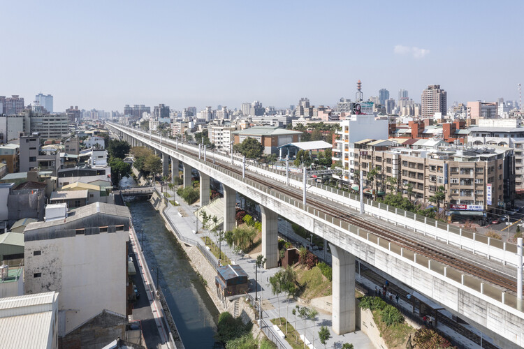
Elevation is often framed as progress, lifting movement above the friction of the city and smoothing circulation into uninterrupted flow. Every act of lifting produces a secondary condition in its wake. Beneath flyovers, metro lines, and railway viaducts, a second ground emerges as shaded, ambiguous, and rarely planned with the same intent as what moves above. These spaces are not incidental leftovers. They are the spatial consequence of a design decision that privileges speed, clearance, and efficiency, redistributing value and visibility across the city in the process.
What lies below is not empty. It is structured, constrained, and defined by infrastructure, left without a clear role. Studies on elevated highways consistently describe these undercroft zones as residual spaces, formed when transport systems are conceived independently of the ground they pass through. An Arup report on spaces beneath viaducts notes how they often disrupt pedestrian continuity while remaining outside formal planning frameworks. Similarly, recent academic reviews of under-flyover environments highlight that these areas are rarely integrated into urban design strategies at all. The result is a peculiar condition: space that is physically present and structurally determined, but programmatically undefined.
Pico House, part of Los Angeles Plaza Historic District. Image by Daniel L. Lu - Own work, CC BY-SA 4.0
Today, the urban form of Los Angeles is characterized by 20th-century sprawl and extensive automotive infrastructure. However, the physical reality of the city's original core reveals a more complex history that is deeply rooted in Hispanic heritage. In fact, Los Angeles did not originate from the standardized American land system that defines most of the United States' territory. Instead, it is a product of the Spanish urban tradition in the Americas, which followed a structure repeated across major cities on the continent. The intersection of these systems created a layered urban geometry and history that remains visible in the city's contemporary street patterns.
When Los Angeleswas founded in 1781 as a pueblo by Felipe de Neve, it was an outpost of the Viceroyalty of New Spain. Viceroyalties were political divisions of the Spanish territories in America, and by the late 18th century, New Spain was vast. It stretched from southern Costa Rica, all the way north to Alta California, bordering the east at the Mississippi River and the newly independent United States of America. At this time, Mexico City functioned as the primary administrative and economic hub, leaving frontier regions like Alta California to rely on a specific triad of settlements: missions (religious), presidios (military), and pueblos (civilian).
Architecture has long been drawn to the idea of lightness. From early modernist experiments that sought to preserve landscapes, elevating buildings has been understood as a way to preserve the ground while maintaining continuity across the terrain. Volumes are lifted on columns, infrastructures detach circulation from the surface, and entire programs are suspended above the ground.
This was formalised in the early twentieth century through Le Corbusier's concept of the pilotis, which proposed the liberation of the ground floor from enclosure. By raising buildings on columns, architects sought to maintain continuity with the terrain, allowing movement, vegetation, and collective use to unfold beneath constructed volumes. The building would occupy the air, while the ground would remain open, accessible, and shared.
Twenty meters tall and four thousand years old, the Western Deffufa towers over the adjacent date orchards and ancient city remains in the desert. It is a former religious and administrative building near the modern-day Sudanese town of Kerma. Its significance is not only in its age and size, but also in that it is one of the oldest mud brick buildings in the world. And as the nearby mud brick houses also attest, earth is a material of continuous use from ancient times to the present. Yet, conversations around contemporary building systems have largely ignored this essential material. Some architects on the continent of Africa, however, are changing that.
In recent decades, cities across the world have seen an increase in the demolition of elevated concrete freeways. Taipei, Seoul, Portland, and Boston, for example, have all seen the rise and fall of these infrastructures to give way to parks and new urban regeneration ideas. In other cases, like Montreal in Canada, some people opposed the freeways even before they were built, effectively rerouting viaducts, preserving heritage, and freeing waterfront views. For San Francisco, in the United States, the story of the Embarcadero Freeway is one of those narratives that serves as a case study of the city's mid-century infrastructural ambition, people's reaction to the project, and its eventual reversal in favor of urban connectivity.
Across Europe and North America, pedestrianisation is increasingly being deployed as a context-specific urban strategy shaped by distinct economic, social, and spatial pressures. As cities continue to reassess the role of streets in the wake of economic shifts, climate pressures, and changing mobility patterns, pedestrianisation is emerging as a tool in current urban transformation efforts. Across London, New York, Houston, and Stockholm, ongoing pedestrian-first projects are testing different pathways toward more resilient and walkable cities, ranging from statutory planning and capital construction to research-driven visioning. London's Oxford Street is advancing through consultation and governance reform to address retail decline; New York's Paseo Park is moving from a temporary pandemic intervention into permanent infrastructure; Houston is accelerating the pedestrianisation of its downtown core in preparation for a global sporting event; and Stockholm's Superline is using design research to rethink the future of an inner-city motorway. These initiatives reveal how pedestrianisation is being actively negotiated, designed, and built today, adapting to local motivations while converging on a shared objective of streets that perform as resilient public spaces rather than traffic conduits.
In recent years, Albania has undergone a rapid and visible transformation, emerging as one of the most active urban environments in Southeast Europe. This growth is not only reflected in the expansion of its built fabric but also in the scale and ambition of new architectural interventions that seek to redefine the country's image. Across its territory, a series of large developments, cultural institutions, and infrastructural projects are being introduced as part of a broader effort to reposition Albania and its capital, Tirana, within regional and international networks.
A significant number of these interventions are being designed by internationally recognized architectural offices, whose presence has become a defining characteristic of the city's current phase of development. Rather than relying primarily on incremental or locally embedded processes, Tirana's transformation is increasingly shaped through externally authored visions that introduce new formal languages, typologies, and urban strategies. These projects often operate as singular objects or large-scale fragments, contributing to a landscape where the city is assembled through distinct and highly visible gestures.
In our current cities, urban density and rising land values often force a choice between large-scale civic buildings and open public space. Traditionally, plazas have been treated as areas surrounding a building's footprint, but this strategy was modified when pilotis were introduced by the early 20th-century modernist movement. While the original intent was to create a sense of lightness that would allow circulation and light to flow beneath a structure, contemporary requirements for seismic loads, fire egress, and heavy occupancies render thin columns insufficient for the needs of current large-scale civic projects.
However, the pursuit of architectural lightness is not a strictly contemporary phenomenon. Following the modernist introduction of pilotis, several mid-century projects began experimenting with the illusion of suspension to achieve civic transparency. In 1953, the National Congress of Honduras in Tegucigalpa, designed by Mario Valenzuela, applied these principles to a legislative setting. The building consists of a solid assembly chamber elevated on a series of slender columns. Because the site sits on a terrace at the end of a sloping street, the resulting void does more than just provide circulation; it frames views of the city, creating the impression that the heavy legislative mass is lightly suspended above the urban fabric.
Beneath the ground lies a material that has quietly shaped the architecture of the modern world. Petroleum is rarely discussed within architectural discourse, yet the extraction, circulation, and consumption of oil have profoundly reorganized the spatial logic of territories. Pipelines, refineries, drilling platforms, ports, highways, and petrochemical complexes form a vast infrastructural landscape that sustains contemporary life, composing a dispersed architecture of energy.
Throughout the twentieth and twenty-first centuries, oil became the material foundation of industrial society. It fueled transportation, powered factories, and supported the growth of cities whose spatial organisation depended on continuous energy flows. Yet the infrastructures that enable these flows rarely become objects of architectural inquiry. Attention remains largely directed toward form, typology, or urban density, while the material systems that sustain these environments tend to remain displaced within the discipline.
At the edge of most cities, beyond the ring roads and interchanges, a different kind of architecture is taking shape. It is not designed to be seen, visited, or remembered. It does not gather people; it moves things. Inside, thousands of parcels travel continuously, being sorted, lifted, scanned, and dispatched with minimal interruption. These buildings rarely enter architectural discourse, yet they are among the most consequential spaces of our time. The defining typology of the 21st century is increasingly the warehouse.
The scale of this transformation is difficult to grasp because it unfolds horizontally, across territories rather than skylines. Global warehouse space now exceeds tens of billions of square feet, expanding rapidly alongside the rise of e-commerce. During the COVID-19 pandemic, demand for logistics infrastructure accelerated by several years, compressing future growth into an already strained present. In India, the warehousing sector continues to grow at double-digit rates, reshaping peri-urban land into storage and distribution corridors. Logistics is no longer a background system; it is a territorial condition.
Documentation work in Deir ez-Zor. Image Courtesy of Deir ez-Zor Heritage Library
The historic city of Deir ez-Zor in eastern Syria has had more than its fair share of calamity after the outbreak of the war in 2011. After seeing destruction caused by fierce battles between armed groups and the central government, as well as occupation by ISIL, the earthquake in February 2023 brought further damage. Behind the headlines, however, is an ancient city tracing its founding to the dawn of civilization on the banks of the Euphrates River, with living architecture from the Ottoman and French Mandate periods. A winner of the ArchDaily 2025 Next Practices Awards, the Deir ez-Zor Heritage Library aims to revitalize the city and support sensitive reconstruction by documenting and promoting its built heritage.


")


")


